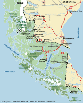
A map of Punta Arenas, Puerto Natales and Parque Nacional Torres Del Paine:

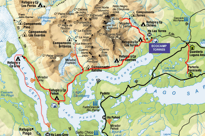
A map of the "W" (in red) within the park:

Breaking down camp is never a fun thing to do. But when you've just gotten spectacular views on a dayhike and you know that there are plenty more to come as soon as you get moving again, at least there is a good motivation to do so.
So, with the sun still climbing over the mountainside, we took down the tent, jammed everything in our packs, and hit the trail again. Our plan was to push on to Refugio Los Cuernos for a big breakfast stop. We wanted to hold off, because we had a lot of ground to cover for the day, and the refugios are a source of free hot water (perfect for making instant oatmeal and coffee, for instance).
As we got out of the Italiano trees, we were again stunned by the beauty and color surrounding us on all sides. Bluish-gray Lago Nordenskjold on our right, dense green hills across the lake, and some brilliantly red-orange flowers that were in full bloom on many of the bushes lining the trails. We were also again stunned by the tangible power of the wind, as it pushed us around on (and a couple times off) the trail.
Although the CONAF map listed the time as 2.5 hours between Italiano and Cuernos, we covered it in exactly 2 hours. This seemed to be a bit of a trend during our hiking times, not because we were moving particularly fast, but more because we were moving quite steadily, plodding up and down the shale scrapple inclines, stomping across the trickling stram bed, and forging through the high (but still colorful) bushes. The ol´Tortoise And The Hare effect, in an amazing environment.
Anyway, after the two hours of hiking, our simple breakfast turned into The Best Instant Oatmeal Ever, paired with The Most Delicious Hot Cocoa Ever. We´d been famished, but were soon (too?) full. Backpack hip-belts do not really comfortably fit over full bellies.
Pictures:
http://good-times.webshots.com/album/555473996ONnqoF
Stepping up to the line of scrimmage with just 4 hours of hiking left to do to get to La Hosteria Las Torres, we called an audible. We were going to push on to Campamento Chileno, another hour closer to our goal for the next day, the Mirador Las Torres. It was perhaps a bit foolish, but we were full of endorphines and Maple Brown Sugar flavoring.
In every other account we´d seen of the W, the four hours between Cuernos and Hostería Las Torres gets very little attention. We feel that this leg has been snubbed. The scenery remains gorgeous (though perhaps nothing particularly novel by this point). You get to cover noticable distance, as you round a mountain to approach a new valley. And you pass through a variety of different environments (boulder-laden streams, high mountain brush, more crumbly rock inclines, boggy marshland). All in all, spectacular, and very sparsely populated by other hikers.
The leg that should perhaps receive more attention in the guide books is the Hostería-Chileno leg. We´d decided to do it somewhat on a whim, not entirely informed, due to some ambiguities on the map. By the time we were done, though, we were physically broken.
Looking somewhat closer on the better map, it became clear that we´d gained roughly 600 meters of elevation. Estimaiting a little bit for the short downhill segments (that were devilishly sprinkled in just so they could add more uphill trail), and it can be said that we hiked the elevation equivalent of climbing to the top of Sears Tower, back down to the ground floor, and then to the top again.
To be fair, and say a few nice words, it was beautiful. We were climbing up the vally of the Río Paine, with rough stone cliffs on one side, and loose glacial deposits lining the trail-side. The river was tumbling far below over giant boulders that had rolled down the hill countless years ago.
But in honesty, we weren´t saying any nice words at the time. What words we could hear from each other over the howling wind were not fit for reproduction, even on the lawless wilds of the Internet. Every stop only made it harder to start again, as our muscles tightened up in the cold wind. The trail became nearly all loose stone, with at least a 45 degree incline on either side (leading down to the aforementioned valley several hundred feet below). And for the first time all trip, both Julie and I felt blisters coming on in our boots.
It was only Julie´s robotic instincts and jogging all of the downhills (don´t forget that we were wearing 30-plus pound packs) that brought us to a sign that told us we had 30 minutes of hiking to do. There were literally tears of joy shed (you, the reader, can guess whose they were). We´d thought we had at least an hour remaining.
Shortly after that, we caught sight of the Refugio, nestled amongst some trees on the opposite side of the valley. Our pulses and strides quickened, and before too long we were crossing a rickety bridge over the river.
As a general note of interest, there are many bridges in Torres Del Paine, crossing a variety of streams and rivers. They are all unique. Sometimes each board within a bridge is unique, making the whole bridge seem as though it were constructed by a handful of 10-year-old kids. Sometimes they even have a few broken boards. But they all serve their purpose well. Bottom line, though, is that they work, and this one over the Rio Paine seemed heaven-sent at the time.
We found the most-sheltered spot we could amongst the trees to set up the tent. After hauling up some rocks from the river to hold down the tent stakes, we were convinced that we wouldn´t get blown away in the night.
One hot shower, one alternating hot and freezing cold shower (mine), and some delicious instant mashed potatoes and salame later, and we were ready for bed.
Actually, not quite ready. We decided to celebrate the day by ordering a bottle of wine from the refugio. We enjoyed the warmth from it, and the refugio fireplace before heading back to our windy tent for a night of much-needed sleep.
Pictures:
http://good-times.webshots.com/album/555472915xqmuAk